
Mapa topográfico Valley
Mapa interactivo
Haga clic en el mapa para ver la altitud.
Acerca de este mapa
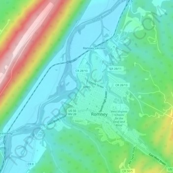
Nombre: Mapa topográfico Valley, altitud, relieve.
Altitud media: 282 m
Altitud mínima: 191 m
Altitud máxima: 536 m
In 1972, the Baltimore and Ohio Railroad was merged into the Chessie System, which planned to close and abandon the South Branch line. The Romney spur through Depot Valley remained in service and was illustrated by the United States Geological Survey on its 1973 Romney Quadrangle topographic map. On October 11, 1978, the Chessie System transferred ownership of the South Branch line to the South Branch Valley Railroad, which in turn was owned and operated by the West Virginia State Rail Authority. During this transition, the Romney spur of the South Branch Valley Railroad was abandoned, after which all rail and commercial activity at Valley ceased.
Otros mapas topográficos
Haga clic en un mapa para ver su topografía, su altitud y su relieve.
Romney Junction
United States > West Virginia > Hampshire County > Romney
Romney Junction, Romney, Hampshire County, West Virginia, 26757, United States
Altitud media: 284 m