
Mapa topográfico Snydertown
Mapa interactivo
Haga clic en el mapa para ver la altitud.
Acerca de este mapa
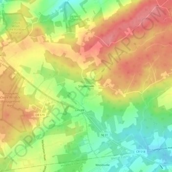
Nombre: Mapa topográfico Snydertown, altitud, relieve.
Altitud media: 110 m
Altitud mínima: 62 m
Altitud máxima: 152 m
Otros mapas topográficos
Haga clic en un mapa para ver su topografía, su altitud y su relieve.
Linvale
United States > New Jersey > Hunterdon County > East Amwell Township
Linvale, East Amwell Township, Hunterdon County, New Jersey, United States
Altitud media: 109 m
Bowne
United States > New Jersey > Hunterdon County > East Amwell Township
Bowne, East Amwell Township, Hunterdon County, New Jersey, United States
Altitud media: 74 m
Larisons Corners
United States > New Jersey > Hunterdon County > East Amwell Township
Larisons Corners, East Amwell Township, Hunterdon County, New Jersey, 08551, United States
Altitud media: 66 m
Wertsville
United States > New Jersey > Hunterdon County > East Amwell Township
Wertsville, East Amwell Township, Hunterdon County, New Jersey, United States
Altitud media: 72 m
Ringoes
United States > New Jersey > Hunterdon County > East Amwell Township
Ringoes, East Amwell Township, Hunterdon County, New Jersey, 08551, United States
Altitud media: 75 m
Rileyville
United States > New Jersey > Hunterdon County > East Amwell Township
Rileyville, East Amwell Township, Hunterdon County, New Jersey, 08525, United States
Altitud media: 125 m