
Mapa topográfico Airdrie
Mapa interactivo
Haga clic en el mapa para ver la altitud.
Acerca de este mapa
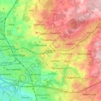
Nombre: Mapa topográfico Airdrie, altitud, relieve.
Lugar: Airdrie, North Lanarkshire, Scotland, ML6 6BU, United Kingdom (55.82578 -4.01959 55.90578 -3.93959)
Altitud media: 136 m
Altitud mínima: 48 m
Altitud máxima: 228 m
Airdrie's name first appeared in the Register of the Great Seal of Scotland (Latin: Registrum Magni Sigilii Regum Scotorum) in 1373 as Ardre. By 1546 it had become Ardry and by 1587 it was known as Ardrie. In 1630 it finally appeared in the Register as Airdrie. Given the topography of the area, the most likely interpretation is that the name derives from the Gaelic An Àrd Ruigh meaning a level height or high pasture land. Another possibility is from the Gaelic An Àrd Àirighe meaning a sheiling, a summer pasture/shepherd's hut. A third possibility is the Gaelic Ard Reidh meaning a high plain. A further, non-Gaelic alternative is the Brythonic, i.e. Cumbric or North Welsh, ard tref (becoming ardre by process of assimilation), meaning a high steading or farmstead, which would date back to the times of the Kingdom of Strathclyde, before the expansion of Gaelic or English speech into the region. Airthrey Castle in Stirlingshire may have a similar derivation.
Otros mapas topográficos
Haga clic en un mapa para ver su topografía, su altitud y su relieve.
Bellshill
United Kingdom > Scotland > North Lanarkshire
Bellshill, North Lanarkshire, Scotland, ML4 1AJ, United Kingdom
Altitud media: 73 m
Cairnhill
United Kingdom > Scotland > North Lanarkshire > Airdrie
Cairnhill, Airdrie, North Lanarkshire, Scotland, ML6 9RW, United Kingdom
Altitud media: 112 m
Cumbernauld
United Kingdom > Scotland > North Lanarkshire
Cumbernauld, North Lanarkshire, Scotland, United Kingdom
Altitud media: 113 m
Viewpark
United Kingdom > Scotland > North Lanarkshire
Viewpark, North Lanarkshire, Scotland, G71 6HL, United Kingdom
Altitud media: 62 m