
Mapa topográfico Temoaya
Mapa interactivo
Haga clic en el mapa para ver la altitud.
Acerca de este mapa
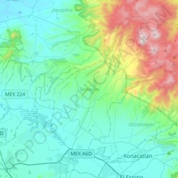
Nombre: Mapa topográfico Temoaya, altitud, relieve.
Lugar: Temoaya, Mexico, 50850, Mexico (19.39625 -99.73111 19.58238 -99.48927)
Altitud media: 2,790 m
Altitud mínima: 2,533 m
Altitud máxima: 3,767 m
The climate is temperate and relatively humid with rains mostly in the summer. Average temperature is 13.4C, ranging between 9 and 35.5C. It is one of the coldest municipalities in the Toluca Valley due to its altitude. Frosts can occur between October and April and morning fog is not uncommon the rest of the year. In the higher elevations there are forest with pine, cedar, oyamel and other trees. In the lower areas there are some broadleaf trees but there are more areas with grass and shrub. Most of the flat areas are cultivated with both field crops and orchards. Very little wildlife remains due to the degradation of most of the ecosystem here. Some small mammals such as squirrels, rabbits and the like remain as well as some bird species. Aquatic life has completely disappeared from the Lerma River area.
Otros mapas topográficos
Haga clic en un mapa para ver su topografía, su altitud y su relieve.
Tejupilco de Hidalgo
Mexico > Mexico > Tejupilco de Hidalgo
Tejupilco de Hidalgo, Tejupilco, Mexico, 51400, Mexico
Altitud media: 1,501 m
San Pablo de las Salinas
Mexico > Mexico > San Pablo de las Salinas
San Pablo de las Salinas, Tultitlán, Mexico, 549131, Mexico
Altitud media: 2,245 m
San Buenaventura
Mexico > Mexico > San Buenaventura
San Buenaventura, Ixtapaluca, Mexico, 56643, Mexico
Altitud media: 2,285 m
Santa Cruz Atizapán.
Mexico > Mexico > Santa Cruz Atizapán.
Santa Cruz Atizapán., Atizapán, Mexico, 52640, Mexico
Altitud media: 2,602 m
El Oro de Hidalgo
Mexico > Mexico > El Oro de Hidalgo
El Oro de Hidalgo, El Oro, Mexico
Altitud media: 2,809 m