
Haz una donación
Mapa topográfico Gangtok
Haga clic en el mapa para ver la altitud.
Haz una donación
Gangtok
Gangtok (Nepali: [gantok] gāntok, Sikkimese: [ɡaŋt̪ʰòk]) is the capital and the most populous city of the Indian state of Sikkim. The seat of eponymous district, Gangtok is in the eastern Himalayan range, at an elevation of 1,650 m (5,410 ft). The city's population of 100,000 consists of the three Sikkimese ethnicities the Bhutias, Lepchas, Nepalis and also plainsmen from other states of India have settled here. Within the higher peaks of the Himalayas and with a year-round mild temperate climate, Gangtok is at the centre of Sikkim's tourism industry.
Haz una donación
Acerca de este mapa
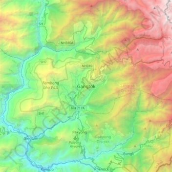
Nombre: Mapa topográfico Gangtok, altitud, relieve.
Lugar: Gangtok, Gangtok subdivision, Gangtok, Sikkim, 737101, India (27.16905 88.45227 27.48905 88.77227)
Altitud media: 1,911 m
Altitud mínima: 283 m
Altitud máxima: 5,193 m
Haz una donación
Otros mapas topográficos
Haga clic en un mapa para ver su topografía, su altitud y su relieve.