
Mapa topográfico County Wicklow
Haga clic en el mapa para ver la altitud.
County Wicklow
The county experiences a narrow annual temperature range. Typical daytime highs range from 17–22 °C (63–72 °F) throughout the county in July and August, with overnight lows in the 11–14 °C (52–57 °F) range, although temperatures in the mountains can be 5–10 °C (41–50 °F) lower. Mean January temperatures range from 7 °C (45 °F) on the coast to 0 °C (32 °F) at high elevations. Precipitation is fairly evenly distributed throughout the year, although the wettest months (October and November) receive roughly twice as much rain as the driest months (February, March and April). The driest area of Wicklow is the northeast corner of the county, which is protected from the prevailing south-westerly winds by the Wicklow Mountains and receives around 750 mm (30 in) of rainfall per year. The coastal region of County Dublin immediately to the north is the driest location in all of Ireland as a result of the rain shadow created by the mountains.
Acerca de este mapa
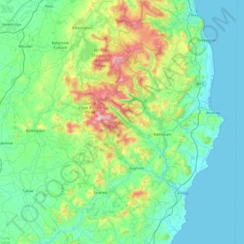
Nombre: Mapa topográfico County Wicklow, altitud, relieve.
Lugar: County Wicklow, Leinster, Ireland (52.68198 -6.79227 53.23442 -5.99758)
Altitud media: 166 m
Altitud mínima: 0 m
Altitud máxima: 927 m
Otros mapas topográficos
Haga clic en un mapa para ver su topografía, su altitud y su relieve.
Galtymore
Ireland > County Limerick > The Municipal District of Cappamore — Kilmallock
Galtymore or Galteemore (Irish: Cnoc Mór na nGaibhlte, meaning 'big hill of the Galtees') is a mountain in the province of Munster, Ireland. At 917.9 metres (3,011 ft 6 in), it is one of Ireland's highest mountains, being the 12th-highest on the Arderin list, and 14th-highest on the Vandeleur-Lynam list.…
Altitud media: 594 m
Aherlow
Ireland > County Limerick > The Municipal District of Cappamore — Kilmallock
Altitud media: 141 m
Kildare Round Tower
A Topographical Dictionary of Ireland states "One of the ancient round towers stood here till 1807 when it was pulled down to make room for the belfry of the church".
Altitud media: 100 m