
Mapa topográfico Hitchins
Mapa interactivo
Haga clic en el mapa para ver la altitud.
Acerca de este mapa
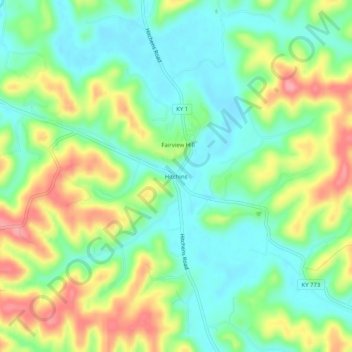
Nombre: Mapa topográfico Hitchins, altitud, relieve.
Lugar: Hitchins, Carter County, Kentucky, 41146, United States (38.26092 -82.94017 38.30092 -82.90017)
Altitud media: 215 m
Altitud mínima: 176 m
Altitud máxima: 278 m
Otros mapas topográficos
Haga clic en un mapa para ver su topografía, su altitud y su relieve.
Wolf
United States > Kentucky > Carter County
Wolf, Carter County, Kentucky, United States
Altitud media: 271 m
Grayson
United States > Kentucky > Carter County
Grayson, Carter County, Kentucky, United States
Altitud media: 208 m
Denton
United States > Kentucky > Carter County
Denton, Carter County, Kentucky, 41132, United States
Altitud media: 232 m
Grahn
United States > Kentucky > Carter County
Grahn, Carter County, Kentucky, 41142, United States
Altitud media: 266 m
Olive Hill
United States > Kentucky > Carter County
Olive Hill, Carter County, Kentucky, 41164, United States
Altitud media: 274 m