
Mapa topográfico Ihrir
Mapa interactivo
Haga clic en el mapa para ver la altitud.
Ihrir
Iherir is located at an elevation of 1,070 metres (3,510 ft) above sea level. Its valley is an oasis containing gueltas and numerous date palms. The town is notable for the dramatic rocky mountain ranges that rise as much as 300 metres (980 ft) on all sides. Prehistoric art dated to 9000 BC is found in the Iheren sites on the nearby Tadjelahine plateau. The valley is protected as a nature park, but protection applies only to the frescoes, not to the fauna or flora. It is also considered a "wetland of global interest" by the Ramsar Convention (2001).
Acerca de este mapa
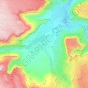
Nombre: Mapa topográfico Ihrir, altitud, relieve.
Lugar: Ihrir, Bordj El Haouas, Djanet District, Djanet, Algeria (25.37678 8.38390 25.41678 8.42390)
Altitud media: 1,218 m
Altitud mínima: 1,047 m
Altitud máxima: 1,420 m
Otros mapas topográficos
Haga clic en un mapa para ver su topografía, su altitud y su relieve.
Tassili n'Ajjer Cultural Park
Algeria > Djanet > Djanet District > Bordj El Haouas
Altitud media: 871 m