
Mapa topográfico Wieżyca
Mapa interactivo
Haga clic en el mapa para ver la altitud.
Acerca de este mapa
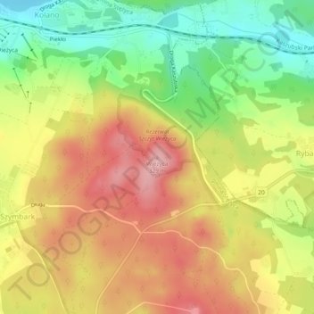
Nombre: Mapa topográfico Wieżyca, altitud, relieve.
Altitud media: 247 m
Altitud mínima: 162 m
Altitud máxima: 325 m
Wieżyca (Kashubian Wieżëca, German Turmberg) is a hill located in northern Poland, in the historical region of Kashubia, some 40 kilometers southwest of Gdańsk. With elevation of 329 metres above sea level, it is the highest peak of central and northern Poland. Its top is covered by a forest, and the hill was the object of pagan cult of ancient Slavs. Wieżyca is a popular tourist area, with a ski lift and a ski slope.