
Mapa topográfico Highland State Recreation Area
Mapa interactivo
Haga clic en el mapa para ver la altitud.
Acerca de este mapa
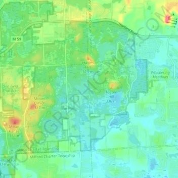
Nombre: Mapa topográfico Highland State Recreation Area, altitud, relieve.
Altitud media: 302 m
Altitud mínima: 282 m
Altitud máxima: 355 m
West of Duck Lake Road in Highland State Recreation Area, a group of small moraines are locally called "mountains"—the highest elevation in the park, Mount Kanzer, is 1,150 feet (350 m) above sea level. The highland for which this recreation area is named is this group of moraines.