
Gracias por apoyar a este sitio ❤️
Haz una donación
Haz una donación
Mapa topográfico Penang Hill
Haga clic en el mapa para ver la altitud.
Gracias por apoyar a este sitio ❤️
Haz una donación
Haz una donación
Penang Hill
A number of hills are covered by Penang Hill, with the highest point being Western Hill that stands at an altitude of 833 meters (2,733 feet) above sea level. Penang Hill is a hilly and forested area that stands out from the lowlands of Malaysia by being hilly and wooded. The area was used as a retreat during the British colonial period, and is now a very popular tourist destination due to its history and heritage.
Gracias por apoyar a este sitio ❤️
Haz una donación
Haz una donación
Acerca de este mapa
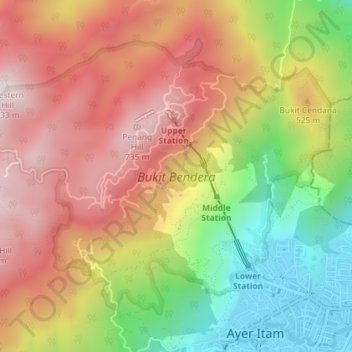
Nombre: Mapa topográfico Penang Hill, altitud, relieve.
Altitud media: 436 m
Altitud mínima: 16 m
Altitud máxima: 804 m
Gracias por apoyar a este sitio ❤️
Haz una donación
Haz una donación