
Mapa topográfico Jedelhausen
Mapa interactivo
Haga clic en el mapa para ver la altitud.
Acerca de este mapa
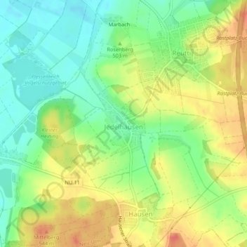
Nombre: Mapa topográfico Jedelhausen, altitud, relieve.
Lugar: Jedelhausen, Neu-Ulm, Landkreis Neu-Ulm, Bayern, Deutschland (48.35048 10.05839 48.35756 10.06550)
Altitud media: 500 m
Altitud mínima: 474 m
Altitud máxima: 529 m
Otros mapas topográficos
Haga clic en un mapa para ver su topografía, su altitud y su relieve.
Schwaighofen
Deutschland > Bayern > Landkreis Neu-Ulm > Neu-Ulm
Schwaighofen, Neu-Ulm, Landkreis Neu-Ulm, Bayern, Deutschland
Altitud media: 475 m
Schloss
Deutschland > Bayern > Landkreis Neu-Ulm > Neu-Ulm > Holzschwang
Schloss, Weißenhorner Straße, Holzschwang, Neu-Ulm, Landkreis Neu-Ulm, Bayern, 89233, Deutschland
Altitud media: 503 m
Gerlenhofen
Deutschland > Bayern > Landkreis Neu-Ulm > Neu-Ulm
Gerlenhofen, Neu-Ulm, Landkreis Neu-Ulm, Bayern, Deutschland
Altitud media: 489 m
Kleine Donau
Deutschland > Bayern > Landkreis Neu-Ulm > Neu-Ulm
Kleine Donau, Neu-Ulm, Landkreis Neu-Ulm, Bayern, 89231, Deutschland
Altitud media: 478 m
Steinheim
Deutschland > Bayern > Landkreis Neu-Ulm > Neu-Ulm
Steinheim, Neu-Ulm, Landkreis Neu-Ulm, Bayern, Deutschland
Altitud media: 473 m