
Haz una donación
Mapa topográfico Whiteswan Lake
Haga clic en el mapa para ver la altitud.
Haz una donación
Acerca de este mapa
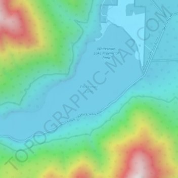
Nombre: Mapa topográfico Whiteswan Lake, altitud, relieve.
Altitud media: 1,392 m
Altitud mínima: 1,131 m
Altitud máxima: 2,229 m
Haz una donación
Otros mapas topográficos
Haga clic en un mapa para ver su topografía, su altitud y su relieve.
Fairmont Hot Springs
Canada > British Columbia > Regional District of East Kootenay > Area F (Columbia Lake/Windermere Lake)
Altitud media: 920 m
Shuswap
Canada > British Columbia > Regional District of East Kootenay > Area F (Columbia Lake/Windermere Lake)
Altitud media: 926 m
Windermere Lake
Canada > British Columbia > Regional District of East Kootenay > Area F (Columbia Lake/Windermere Lake) > Windermere
Altitud media: 1,010 m
Whiteswan Lake Provincial Park
Canada > British Columbia > Regional District of East Kootenay > Area F (Columbia Lake/Windermere Lake)
Altitud media: 1,667 m
Haz una donación
Mount Worthington
Canada > British Columbia > Regional District of East Kootenay > Area F (Columbia Lake/Windermere Lake)
Altitud media: 2,421 m
Lockwood Peak
Canada > British Columbia > Regional District of East Kootenay > Area F (Columbia Lake/Windermere Lake)
Altitud media: 2,225 m
Panorama Mountain Village
Canada > British Columbia > Regional District of East Kootenay > Area F (Columbia Lake/Windermere Lake)
Altitud media: 1,412 m
Columbia Lake
Canada > British Columbia > Regional District of East Kootenay > Area F (Columbia Lake/Windermere Lake)
Altitud media: 1,249 m
Haz una donación
Windermere
Canada > British Columbia > Regional District of East Kootenay > Area F (Columbia Lake/Windermere Lake)
Altitud media: 842 m