
Mapa topográfico Stegelitz
Mapa interactivo
Haga clic en el mapa para ver la altitud.
Acerca de este mapa
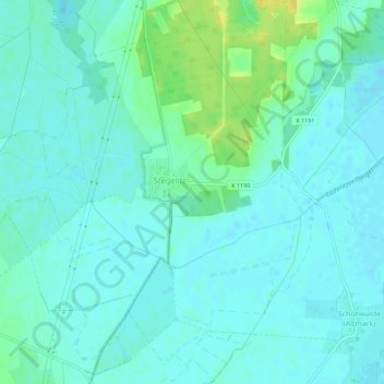
Nombre: Mapa topográfico Stegelitz, altitud, relieve.
Lugar: Stegelitz, Tangerhütte, Stendal, Sachsen-Anhalt, Deutschland (52.45831 11.74839 52.49288 11.78700)
Altitud media: 40 m
Altitud mínima: 34 m
Altitud máxima: 57 m
Otros mapas topográficos
Haga clic en un mapa para ver su topografía, su altitud y su relieve.
Groß Schwarzlosen
Deutschland > Sachsen-Anhalt > Tangerhütte
Groß Schwarzlosen, Tangerhütte, Stendal, Sachsen-Anhalt, Deutschland
Altitud media: 52 m
Weißewarte
Deutschland > Sachsen-Anhalt > Tangerhütte > Weißewarte
Weißewarte, Tangerhütte, Stendal, Sachsen-Anhalt, Deutschland
Altitud media: 37 m
Kehnert
Deutschland > Sachsen-Anhalt > Tangerhütte
Kehnert, Tangerhütte, Stendal, Sachsen-Anhalt, Deutschland
Altitud media: 43 m