
Haz una donación
Mapa topográfico Besenfeld
Haga clic en el mapa para ver la altitud.
Haz una donación
Acerca de este mapa
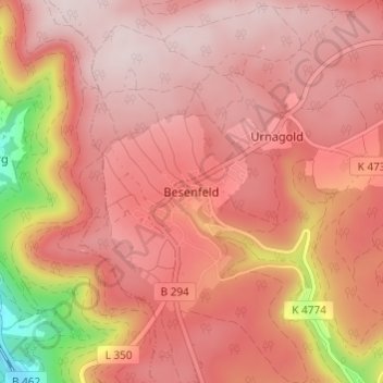
Nombre: Mapa topográfico Besenfeld, altitud, relieve.
Altitud media: 779 m
Altitud mínima: 479 m
Altitud máxima: 893 m
Haz una donación
Otros mapas topográficos
Haga clic en un mapa para ver su topografía, su altitud y su relieve.
Peterzell
Germany > Baden-Württemberg > Landkreis Freudenstadt > Alpirsbach
The township (Stadt) covers an area of 64.55 square kilometers (24.92 mi2) of the Freudenstadt district, within the state of Baden-Württemberg and the Federal Republic of Germany. Alpirsbach is physically located in the upper Kinzig valley, in the Central Black Forest, but also in the Upper Gäu (de) at the…
Altitud media: 639 m
Haz una donación
Friedrichsturm
Germany > Baden-Württemberg > Landkreis Freudenstadt > Freudenstadt
Altitud media: 753 m
Dietersweiler
Germany > Baden-Württemberg > Landkreis Freudenstadt > Freudenstadt
Altitud media: 636 m
Haz una donación