
Haz una donación
Mapa topográfico Pangil
Haga clic en el mapa para ver la altitud.
Haz una donación
Pangil
The municipality is strategically situated at the southern tip of Sierra Madre mountain range (six barangays) and along the eastern margin of Jalajala Peninsula and just west of the northwestern shore of the easternmost major embayment of Laguna de Bay (two barangays). Its narrow strip of territory traverses in its length by Pangil River (12.5 km long), valued for its pristine and abundant water contributing to its domestic, agricultural, ecotourism and other potential economic uses like bulk water and hydropower. Its topography is generally flat in between rolling and steep hills.
Haz una donación
Acerca de este mapa
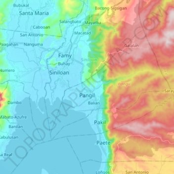
Nombre: Mapa topográfico Pangil, altitud, relieve.
Lugar: Pangil, Laguna, Calabarzon, 4018, Philippines (14.36277 121.39184 14.45636 121.53830)
Altitud media: 164 m
Altitud mínima: -5 m
Altitud máxima: 558 m
Haz una donación
Otros mapas topográficos
Haga clic en un mapa para ver su topografía, su altitud y su relieve.
Haz una donación
Haz una donación
Haz una donación
Haz una donación
Haz una donación
Haz una donación