
Mapa topográfico Riddle
Mapa interactivo
Haga clic en el mapa para ver la altitud.
Acerca de este mapa
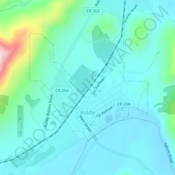
Nombre: Mapa topográfico Riddle, altitud, relieve.
Lugar: Riddle, Douglas County, Oregon, United States of America (42.94641 -123.37653 42.96311 -123.35149)
Altitud media: 246 m
Altitud mínima: 195 m
Altitud máxima: 504 m
Riddle is about 25 miles (40 km) south of Roseburg and 220 miles (350 km) south of Portland. It lies about 4 miles (6.4 km) west of Oregon Route 99 (Interstate 5) at an elevation of about 700 feet (210 m) above sea level. Cow Creek flows by Riddle before entering the nearby South Umpqua River.