
Mapa topográfico Nowy Targ
Mapa interactivo
Haga clic en el mapa para ver la altitud.
Acerca de este mapa
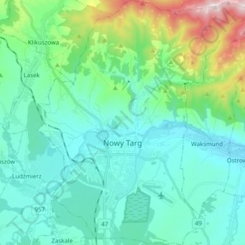
Nombre: Mapa topográfico Nowy Targ, altitud, relieve.
Altitud media: 679 m
Altitud mínima: 567 m
Altitud máxima: 1,135 m
According to the Köppen climate classification, Nowy Targ straddles the border of the Warm Summer Continental (Dfb) and Subarctic (Dfc) climates, with most of the city falling in the Dfb group. The Dfc climate is only found above 800 metres of elevation within Nowy Targ.