
Mapa topográfico Holalkere
Mapa interactivo
Haga clic en el mapa para ver la altitud.
Acerca de este mapa
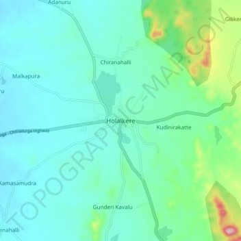
Nombre: Mapa topográfico Holalkere, altitud, relieve.
Altitud media: 715 m
Altitud mínima: 662 m
Altitud máxima: 948 m
Holalkere is located at 14°02′N 76°11′E / 14.03°N 76.18°E / 14.03; 76.18. It has an average elevation of 711 metres (2332 feet).