
Mapa topográfico Town of Watertown
Mapa interactivo
Haga clic en el mapa para ver la altitud.
Acerca de este mapa
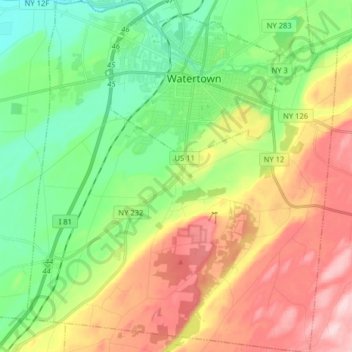
Nombre: Mapa topográfico Town of Watertown, altitud, relieve.
Lugar: Town of Watertown, Jefferson County, New York, United States (43.88506 -75.98706 44.00025 -75.84560)
Altitud media: 189 m
Altitud mínima: 87 m
Altitud máxima: 340 m
Otros mapas topográficos
Haga clic en un mapa para ver su topografía, su altitud y su relieve.
Village of Evans Mills
United States > New York > Jefferson County
Village of Evans Mills, Town of Le Ray, Jefferson County, New York, United States
Altitud media: 139 m
Just Room Enough Island
United States > New York > Jefferson County > Village of Alexandria Bay
Just Room Enough Island, Village of Alexandria Bay, Town of Alexandria, Jefferson County, New York, United States
Altitud media: 78 m
Village of Black River
United States > New York > Jefferson County
Village of Black River, Town of Le Ray, Jefferson County, New York, United States
Altitud media: 193 m
Village of Philadelphia
United States > New York > Jefferson County
Village of Philadelphia, Town of Philadelphia, Jefferson County, New York, 13673, United States
Altitud media: 149 m
Village of Theresa
United States > New York > Jefferson County > Town of Theresa
Village of Theresa, Town of Theresa, Jefferson County, New York, 13691, United States
Altitud media: 121 m
Black River
United States > New York > Jefferson County > Black River
Black River, Le Ray, Jefferson County, New York, 13612, United States
Altitud media: 189 m
Whites Bay
United States > New York > Jefferson County
Whites Bay, Henderson, Jefferson County, New York, 13651, United States
Altitud media: 91 m