
Gracias por apoyar a este sitio ❤️
Haz una donación
Haz una donación
Mapa topográfico Whittingham
Haga clic en el mapa para ver la altitud.
Gracias por apoyar a este sitio ❤️
Haz una donación
Haz una donación
Acerca de este mapa
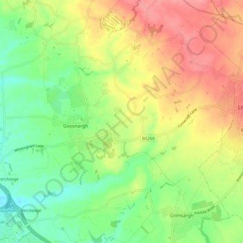
Nombre: Mapa topográfico Whittingham, altitud, relieve.
Lugar: Whittingham, Preston, Lancashire, England, United Kingdom (53.80720 -2.70448 53.84553 -2.60790)
Altitud media: 78 m
Altitud mínima: 39 m
Altitud máxima: 124 m
Gracias por apoyar a este sitio ❤️
Haz una donación
Haz una donación
Otros mapas topográficos
Haga clic en un mapa para ver su topografía, su altitud y su relieve.
Gracias por apoyar a este sitio ❤️
Haz una donación
Haz una donación
Gracias por apoyar a este sitio ❤️
Haz una donación
Haz una donación
Gracias por apoyar a este sitio ❤️
Haz una donación
Haz una donación
Gracias por apoyar a este sitio ❤️
Haz una donación
Haz una donación