
Mapa topográfico Miliana
Mapa interactivo
Haga clic en el mapa para ver la altitud.
Acerca de este mapa
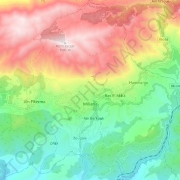
Nombre: Mapa topográfico Miliana, altitud, relieve.
Lugar: Miliana, Miliana District, Aïn Defla, Algeria (36.27210 2.19244 36.34942 2.27411)
Altitud media: 840 m
Altitud mínima: 317 m
Altitud máxima: 1,564 m
Due to its position in mountainous terrain, the elevation of Miliana differs greatly, ranging from 430 metres (1,410 ft) to 870 metres (2,850 ft). It is built on a rocky shelf with steep edges on the southern slopes of Mount Zaccar Rherbi, which covers its entire northern border and reaches 1,550 metres (5,090 ft). There is also a smaller ridge to the south that reaches 700 metres (2,300 ft), separating Miliana from Khemis Miliana. The area around the town is well forested. To the east and south is the Chélif River Valley, and to the west is a large plateau that stretches to the Ouarsenis range.