
Mapa topográfico Barajevo
Mapa interactivo
Haga clic en el mapa para ver la altitud.
Acerca de este mapa
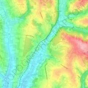
Nombre: Mapa topográfico Barajevo, altitud, relieve.
Altitud media: 175 m
Altitud mínima: 116 m
Altitud máxima: 261 m
The municipality is located in the lower northern part of Šumadija, southeast of the Belgrade, with an elevation spanning from 140 meters to 364 meters. Most of the municipal territory belongs to the drainage area of the Turija river, right tributary of the Peštan river, which in turn flows into the Kolubara, thus whole area geographically gravitates to the Kolubara region. The cultural festival, "Barlet" (Barajevo summer) is held annually in Barajevo.