
Mapa topográfico Smiths Grove
Mapa interactivo
Haga clic en el mapa para ver la altitud.
Acerca de este mapa
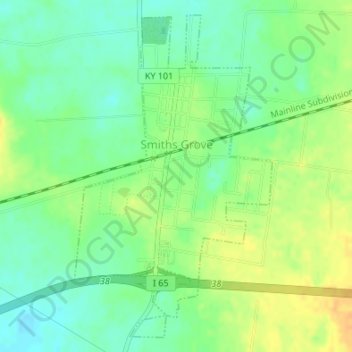
Nombre: Mapa topográfico Smiths Grove, altitud, relieve.
Lugar: Smiths Grove, Warren County, Kentucky, United States (37.03773 -86.21758 37.06244 -86.19858)
Altitud media: 193 m
Altitud mínima: 179 m
Altitud máxima: 210 m
Otros mapas topográficos
Haga clic en un mapa para ver su topografía, su altitud y su relieve.
Bowling Green
United States > Kentucky > Warren County
Bowling Green, Warren County, Kentucky, 42101, United States
Altitud media: 169 m
Rockfield
United States > Kentucky > Warren County
Rockfield, Warren County, Kentucky, 42274, United States
Altitud media: 179 m
Plano
United States > Kentucky > Warren County
Plano, Warren County, Kentucky, 42102, United States
Altitud media: 182 m
Richardsville
United States > Kentucky > Warren County
Richardsville, Warren County, Kentucky, United States
Altitud media: 182 m
Alvaton
United States > Kentucky > Warren County
Alvaton, Warren County, Kentucky, 42122, United States
Altitud media: 182 m
Springhill
United States > Kentucky > Warren County > Bowling Green > Springhill
Springhill, Bowling Green, Warren County, Kentucky, 42101-1000, United States
Altitud media: 155 m