
Mapa topográfico Eschental
Mapa interactivo
Haga clic en el mapa para ver la altitud.
Acerca de este mapa
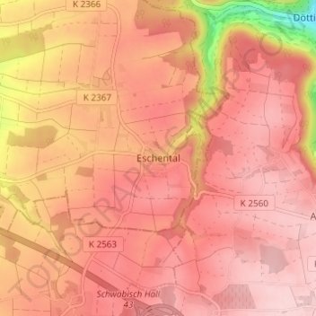
Nombre: Mapa topográfico Eschental, altitud, relieve.
Altitud media: 394 m
Altitud mínima: 244 m
Altitud máxima: 449 m
Otros mapas topográficos
Haga clic en un mapa para ver su topografía, su altitud y su relieve.
Öhringen
Duitsland > Baden-Württemberg > Hohenlohekreis
Öhringen, Verwaltungsgemeinschaft Öhringen, Hohenlohekreis, Baden-Württemberg, 74613, Duitsland
Altitud media: 282 m
Rossach
Duitsland > Baden-Württemberg > Hohenlohekreis > Schöntal > Rossach
Rossach, Schöntal, Hohenlohekreis, Baden-Württemberg, 74241, Duitsland
Altitud media: 304 m