Geolocalizar

Mapa topográfico Vasant Kunj

Mapa interactivo

Haga clic en el mapa para ver la altitud.

Acerca de este mapa

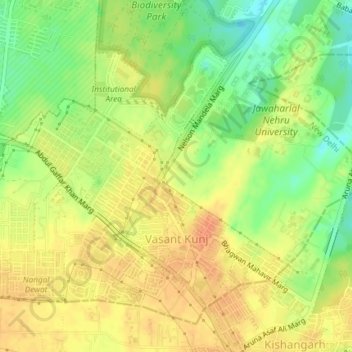
Nombre: Mapa topográfico Vasant Kunj, altitud, relieve.

Lugar: Vasant Kunj, Vasant Vihar Tehsil, New Delhi, Delhi, India (28.52294 77.12763 28.54683 77.16452)

Altitud media: 261 m

Altitud mínima: 237 m

Altitud máxima: 278 m

Otros mapas topográficos

Haga clic en un mapa para ver su topografía, su altitud y su relieve.

Ramakrishna Puram

India > Delhi > New Delhi

Ramakrishna Puram, Vasant Vihar Tehsil, New Delhi, Delhi, India

Altitud media: 235 m

DIZ Area

India > Delhi > New Delhi

DIZ Area, Chanakya Puri Tehsil, New Delhi, Delhi, India

Altitud media: 228 m

Central Ridge Reserve Forest

India > Delhi > New Delhi

Central Ridge Reserve Forest, Delhi Cantonment, New Delhi, Delhi, India

Altitud media: 235 m

Sector 5

India > Delhi > New Delhi

Sector 5, Ramakrishna Puram, Vasant Vihar Tehsil, New Delhi, Delhi, India

Altitud media: 236 m

Pusa

India > Delhi > New Delhi

Pusa, Delhi Cantonment, New Delhi, Delhi, India

Altitud media: 227 m

Chanakyapuri

India > Delhi > New Delhi

Chanakyapuri, Chanakya Puri Tehsil, New Delhi, Delhi, 110021, India

Altitud media: 228 m

Vasant Vihar

India > Delhi > New Delhi

Vasant Vihar, Delhi Cantonment, New Delhi, Delhi, 110057, India

Altitud media: 244 m

Lodhi Gardens

India > Delhi > New Delhi

Lodhi Gardens, Rabindra Nagar, New Delhi, Chanakya Puri Tehsil, Delhi, India

Altitud media: 214 m

Rangpuri

India > Delhi > New Delhi > Rangpuri

Rangpuri, New Delhi, Delhi, 110037, India

Altitud media: 244 m