
Haz una donación
Mapa topográfico Farlam
Haga clic en el mapa para ver la altitud.
Haz una donación
Farlam
Farlam was originally divided into two townships, East Farlam and West Farlam, with a combined population in 1811 of 672 inhabitants and 115 houses. Hallbankgate and Kirkhouse were two hamlets located within the township of East Farlam, the former four miles south east of Brampton, and the latter, where the church stands, half-a-mile east of the village. Milton was a small village in West Farlam and is now in Brampton parish. The whole parish has a high elevation and topographically is quite hilly with an area in 1847 of 5,680 acres.
Haz una donación
Acerca de este mapa
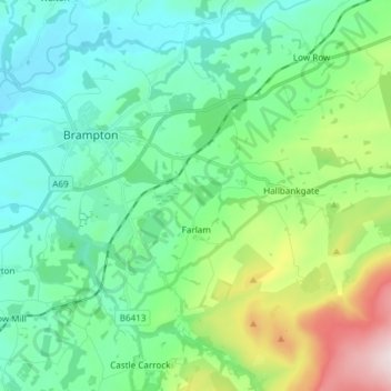
Nombre: Mapa topográfico Farlam, altitud, relieve.
Lugar: Farlam, Carlisle, Cumbria, England, United Kingdom (54.90964 -2.71009 54.94788 -2.56018)
Altitud media: 167 m
Altitud mínima: 28 m
Altitud máxima: 611 m
Haz una donación
Otros mapas topográficos
Haga clic en un mapa para ver su topografía, su altitud y su relieve.