
Gracias por apoyar a este sitio ❤️
Haz una donación
Haz una donación
Mapa topográfico Langenhagen
Haga clic en el mapa para ver la altitud.
Gracias por apoyar a este sitio ❤️
Haz una donación
Haz una donación
Acerca de este mapa
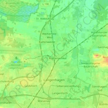
Nombre: Mapa topográfico Langenhagen, altitud, relieve.
Lugar: Langenhagen, Region Hannover, Lower Saxony, Germany (52.42285 9.62885 52.50638 9.77664)
Altitud media: 51 m
Altitud mínima: 38 m
Altitud máxima: 72 m
Gracias por apoyar a este sitio ❤️
Haz una donación
Haz una donación
Otros mapas topográficos
Haga clic en un mapa para ver su topografía, su altitud y su relieve.
Gracias por apoyar a este sitio ❤️
Haz una donación
Haz una donación
Gracias por apoyar a este sitio ❤️
Haz una donación
Haz una donación
Hanover
Germany > Lower Saxony > Region Hannover > Hanover
In 1636 George, Duke of Brunswick-Lüneburg, ruler of the Brunswick-Lüneburg principality of Calenberg, moved his residence to Hanover. The Dukes of Brunswick-Lüneburg were elevated by the Holy Roman Emperor to the rank of Prince-Elector in 1692 and this elevation was confirmed by the Imperial Diet in 1708.…
Altitud media: 70 m