
Mapa topográfico Neilston
Haga clic en el mapa para ver la altitud.
Neilston
The topography of the areas around Neilston are varied. To the east, the land is relatively flat, but to the south and west it is steeper, rising to heights of 400–900 ft (122–274 m) above the level of the River Clyde. The highest points in the surrounding areas are Neilston Pad and the Corkendale-law, at about 853 and 900 ft (260 and 274 m) above sea level, respectively. Neilston Pad is characterised by a craggy face on its eastern side. Between these hills is the valley of the River Levern. In this valley is the A736 to Barrhead. The soil in the eastern parts of Neilston is a dry loam, occasionally intermixed with gravel. The soil in the hills near Neilston is considered to be largely infertile, whilst to the south and southwest there is an expansive moorland which extends as far as Darvel and Strathaven. The local geology is represented by basalt. The surrounding landscape is dominated by Duncarnock, the resistant core of an ancient and long extinct volcano, known locally as 'the Craigie'.
Acerca de este mapa
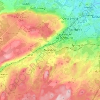
Nombre: Mapa topográfico Neilston, altitud, relieve.
Lugar: Neilston, East Renfrewshire, Scotland, G78 3NJ, United Kingdom (55.74467 -4.46635 55.82467 -4.38635)
Altitud media: 149 m
Altitud mínima: 21 m
Altitud máxima: 277 m
Otros mapas topográficos
Haga clic en un mapa para ver su topografía, su altitud y su relieve.
Dams to Darnley Country Park
United Kingdom > Scotland > East Renfrewshire > Barrhead
Altitud media: 77 m