
Mapa topográfico Al-Azhar Park
Mapa interactivo
Haga clic en el mapa para ver la altitud.
Acerca de este mapa
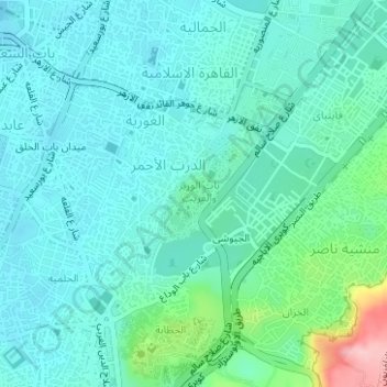
Nombre: Mapa topográfico Al-Azhar Park, altitud, relieve.
Lugar: Al-Azhar Park, El-Darb El-Ahmar, Cairo, Egypt (30.03658 31.26111 30.04439 31.26896)
Altitud media: 54 m
Altitud mínima: 20 m
Altitud máxima: 202 m
In 1984, Aga Khan IV was visiting Cairo on a conference. From his hotel balcony; Al-Darassa hill (Arabic: هضبة الدراسة) was visible: mounts of wreckage and ruins amassed during 500 years. He decided to intervene and offer that medieval area via the Historic Cities Support Programme the much-needed gift of an oasis in this urban desert. The sum of 30 million dollars was allocated to the project and put in the qualified hand of a local architecture and urbanism office: Sites International. The site posed several technical challenges; half a millennium of debris was at hand. Works of excavation, grading and replacement with appropriate fill began in 1992. "Over 765,000 m3 was taken out of the Park and 160,000 m3 was used as fill elsewhere on site. A further 605,000 m3 was subjected to geotechnical treatment (sieving, washing, etc.) and mixed with 60,000 m3 of special sand and topsoil to enable the site to be covered with a layer of “good” soil from 0.5 to 2.0 meters deep. A total of 1.5 million cubic meters of rubble and soil were moved, which represents over 80,000 truckloads." While the designers grappled with the technical difficulties at hand posed by the terrain and soil the government introduces an additional unexpected constraint at halfway through the process: three cisterns were to be integrated into the terrain to improve the supply of potable water to the city of Cairo. Works had to be interrupted and the design revised to integrate the new three elements. The new revised layout of the park was then carefully designed according to the landscape of the hill and the new 3 water tanks. It is mainly divided in five sections according to slope inclination, leaving us with: 2 hills (southern and northern), a rolling topography hill to the east, a flat area north and a western steep slope.
Otros mapas topográficos
Haga clic en un mapa para ver su topografía, su altitud y su relieve.
Diplomaseyeen District
Diplomaseyeen District, Cairo, 11835, Egypt
Altitud media: 296 m
Fustat
Egypt > Cairo > Cairo > EL Sheikh Mubarak
Fustat, Masr Al-Qadima, EL Sheikh Mubarak, Cairo, Egypt
Altitud media: 29 m
Rhoda Island
Egypt > Cairo > Cairo > EL Sheikh Mubarak
Rhoda Island, EL Sheikh Mubarak, Cairo, Egypt
Altitud media: 26 m
Puerta Bab Al Futuh
Puerta Bab Al Futuh, Al Moez Ldin Allah Al Fatemi Street, Bab El Fetouh, El-Gamaliyya, Cairo, 11681, Egypt
Altitud media: 34 m
Salah El Din Citadel
Egypt > Cairo > Cairo > El Giyushi
Salah El Din Citadel, Al Waldh Pasha Alley, El Hataba, El-Darb El-Ahmar, Cairo, 11655, Egypt
Altitud media: 65 m
Fostat garden
Egypt > Cairo > Cairo > EL Sheikh Mubarak
Fostat garden, Masr Al-Qadima, EL Sheikh Mubarak, Cairo, Egypt
Altitud media: 33 m