
Mapa topográfico Cypher
Mapa interactivo
Haga clic en el mapa para ver la altitud.
Acerca de este mapa
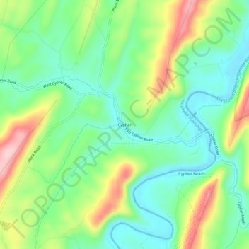
Nombre: Mapa topográfico Cypher, altitud, relieve.
Altitud media: 336 m
Altitud mínima: 265 m
Altitud máxima: 466 m
Otros mapas topográficos
Haga clic en un mapa para ver su topografía, su altitud y su relieve.
Yellow Creek
United States > Pennsylvania > Bedford County > Hopewell Township > Yellow Creek
Yellow Creek, Hopewell Township, Bedford County, Pennsylvania, 16650, United States
Altitud media: 343 m