
Mapa topográfico Halloughton
Mapa interactivo
Haga clic en el mapa para ver la altitud.
Acerca de este mapa
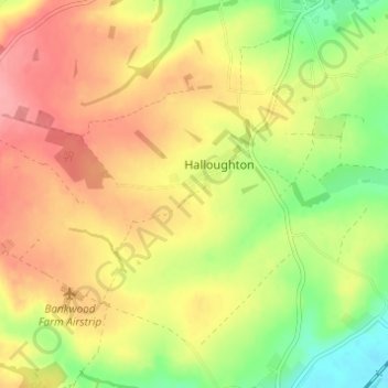
Nombre: Mapa topográfico Halloughton, altitud, relieve.
Altitud media: 64 m
Altitud mínima: 15 m
Altitud máxima: 104 m
Otros mapas topográficos
Haga clic en un mapa para ver su topografía, su altitud y su relieve.
Syerston
United Kingdom > England > Newark and Sherwood > Nottinghamshire
Syerston, Newark and Sherwood, Nottinghamshire, East Midlands, England, United Kingdom
Altitud media: 40 m
Fiskerton cum Morton
United Kingdom > England > Newark and Sherwood > Nottinghamshire
Fiskerton cum Morton, Newark and Sherwood, Nottinghamshire, East Midlands, England, United Kingdom
Altitud media: 21 m
Ollerton and Boughton CP
United Kingdom > England > Newark and Sherwood > Nottinghamshire
Ollerton and Boughton CP, Newark and Sherwood, Nottinghamshire, East Midlands, England, United Kingdom
Altitud media: 52 m
River Greet
United Kingdom > England > Newark and Sherwood > Nottinghamshire
River Greet, Newark and Sherwood, Nottinghamshire, East Midlands, England, NG25 0TT, United Kingdom
Altitud media: 15 m
Balderton
United Kingdom > England > Newark and Sherwood > Nottinghamshire
Balderton, Newark and Sherwood, Nottinghamshire, East Midlands, England, United Kingdom
Altitud media: 20 m