
Haz una donación
Mapa topográfico Rameswaram
Haga clic en el mapa para ver la altitud.
Haz una donación
Rameswaram
Rameswaram has an average elevation of 10 m (33 ft). The island is spread across an area of 61.8 km2 (23.9 sq mi) and is in the shape of a conch. 74% of the area has sandy soil due to the presence of sea and it has many islands surrounding it, the Palk Strait in the north west and Gulf of Mannar in the south East. The Ramanathaswamy Temple occupies major area of Rameswaram. The beach of Rameswaram is featured with no waves at all – the sea waves rise to a maximum height of 3 cm (0.10 ft) and the view looks like a very big river. Rameswaram has dry tropical climate with low humidity, with average monthly rainfall of 75.73 mm (2.981 in), mostly from North-East monsoon from October to January. The highest ever temperature recorded at Pamban station was 37 °C and the lowest was 17 °C.
Haz una donación
Acerca de este mapa
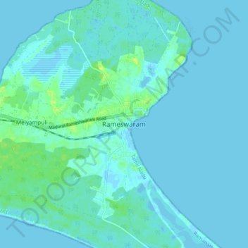
Nombre: Mapa topográfico Rameswaram, altitud, relieve.
Lugar: Rameswaram, Ramanathapuram, Tamil Nadu, 623526, India (9.24447 79.27256 9.32447 79.35256)
Altitud media: 3 m
Altitud mínima: -2 m
Altitud máxima: 15 m
Haz una donación
Otros mapas topográficos
Haga clic en un mapa para ver su topografía, su altitud y su relieve.