
Gracias por apoyar a este sitio ❤️
Haz una donación
Haz una donación
Mapa topográfico Warlingham
Haga clic en el mapa para ver la altitud.
Gracias por apoyar a este sitio ❤️
Haz una donación
Haz una donación
Warlingham
Elevations vary from 110m AOD at Woldingham Road, at the southernmost point of the parish, with a gentle increase in height through the village along the main road heading to the southeast, to the highest elevation (199.6m) at Limpsfield Road.
Gracias por apoyar a este sitio ❤️
Haz una donación
Haz una donación
Acerca de este mapa
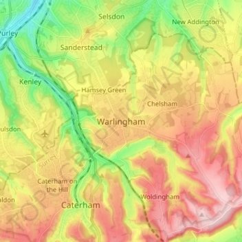
Nombre: Mapa topográfico Warlingham, altitud, relieve.
Altitud media: 165 m
Altitud mínima: 57 m
Altitud máxima: 271 m
Gracias por apoyar a este sitio ❤️
Haz una donación
Haz una donación