
Mapa topográfico Penny
Mapa interactivo
Haga clic en el mapa para ver la altitud.
Acerca de este mapa
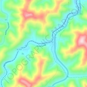
Nombre: Mapa topográfico Penny, altitud, relieve.
Lugar: Penny, Pike County, Kentucky, 41560, United States (37.33927 -82.58154 37.37927 -82.54154)
Altitud media: 378 m
Altitud mínima: 231 m
Altitud máxima: 638 m
Otros mapas topográficos
Haga clic en un mapa para ver su topografía, su altitud y su relieve.
Elkhorn City
United States > Kentucky > Pike County
Elkhorn City, Pike County, Kentucky, United States
Altitud media: 364 m
Jonancy
United States > Kentucky > Pike County
Jonancy, Pike County, Kentucky, 41538, United States
Altitud media: 399 m
McAndrews
United States > Kentucky > Pike County
McAndrews, Pike County, Kentucky, 41567, United States
Altitud media: 374 m
Pikeville
United States > Kentucky > Pike County
Pikeville, Pike County, Kentucky, 41501, United States
Altitud media: 338 m
Pleasant Valley
United States > Kentucky > Pike County > Pikeville
Pleasant Valley, Pikeville, Pike County, Kentucky, 41501, United States
Altitud media: 315 m
Mouthcard
United States > Kentucky > Pike County
Mouthcard, Pike County, Kentucky, 41548, United States
Altitud media: 393 m
Toler
United States > Kentucky > Pike County
Toler, Pike County, Kentucky, 25661, United States
Altitud media: 320 m
Phyllis
United States > Kentucky > Pike County
Phyllis, Pike County, Kentucky, 41554, United States
Altitud media: 406 m
Pikeville
United States > Kentucky > Pike County > Pikeville > Pikeville
Pikeville, Pike County, Kentucky, 41501, United States
Altitud media: 312 m
Turkey Creek
United States > Kentucky > Pike County > Turkey Creek
Turkey Creek, Pike County, Kentucky, 41514, United States
Altitud media: 312 m
Lick Creek
United States > Kentucky > Pike County
Lick Creek, Pike County, Kentucky, 41540, United States
Altitud media: 430 m