
Gracias por apoyar a este sitio ❤️
Haz una donación
Haz una donación
Mapa topográfico Butajira
Haga clic en el mapa para ver la altitud.
Gracias por apoyar a este sitio ❤️
Haz una donación
Haz una donación
Acerca de este mapa
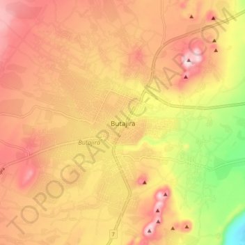
Nombre: Mapa topográfico Butajira, altitud, relieve.
Altitud media: 2,078 m
Altitud mínima: 1,861 m
Altitud máxima: 2,220 m
Gracias por apoyar a este sitio ❤️
Haz una donación
Haz una donación
Otros mapas topográficos
Haga clic en un mapa para ver su topografía, su altitud y su relieve.
Lake Chamo
Ethiopia > Southern Nations, Nationalities, and Peoples
Lake Chamo (Amharic: ቻሞ ሐይቅ) is a lake in the Southern Nations, Nationalities, and Peoples' Region of southern Ethiopia. Located in the Main Ethiopian Rift, it is at an elevation of 1,110 meters. The Chamo lake is just to the south of Lake Abaya and the city of Arba Minch, east of the Guge Mountains,…
Altitud media: 1,185 m
Gracias por apoyar a este sitio ❤️
Haz una donación
Haz una donación