
Gracias por apoyar a este sitio ❤️
Haz una donación
Haz una donación
Mapa topográfico Apache
Haga clic en el mapa para ver la altitud.
Gracias por apoyar a este sitio ❤️
Haz una donación
Haz una donación
Acerca de este mapa
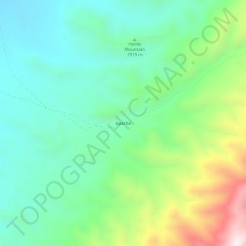
Nombre: Mapa topográfico Apache, altitud, relieve.
Lugar: Apache, Otero County, New Mexico, United States (33.30536 -105.92277 33.34536 -105.88277)
Altitud media: 1,957 m
Altitud mínima: 1,703 m
Altitud máxima: 2,573 m
Gracias por apoyar a este sitio ❤️
Haz una donación
Haz una donación
Otros mapas topográficos
Haga clic en un mapa para ver su topografía, su altitud y su relieve.
White Sands National Park
United States > New Mexico > Otero County
The first US Army exploration of south-central New Mexico was led by a party of topographical engineering officers in 1849. They passed west of the San Andres Mountains and Organ Mountains. A lieutenant was dispatched east across the basin with a scouting party to map a potential military wagon route to the…
Altitud media: 1,214 m