
Mapa topográfico New Salem
Mapa interactivo
Haga clic en el mapa para ver la altitud.
Acerca de este mapa
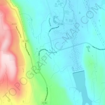
Nombre: Mapa topográfico New Salem, altitud, relieve.
Altitud media: 212 m
Altitud mínima: 102 m
Altitud máxima: 504 m
Otros mapas topográficos
Haga clic en un mapa para ver su topografía, su altitud y su relieve.
Wolf Hill
United States > New York > Albany County > Town of New Scotland
Wolf Hill, Town of New Scotland, Albany County, New York, 12041, United States
Altitud media: 385 m
Unionville
United States > New York > Albany County > Town of New Scotland
Unionville, Town of New Scotland, Albany County, New York, 12067, United States
Altitud media: 88 m
Clarksville
United States > New York > Albany County > Town of New Scotland
Clarksville, Town of New Scotland, Albany County, New York, 12041, United States
Altitud media: 243 m
Tarrytown
United States > New York > Albany County > Town of New Scotland
Tarrytown, Town of New Scotland, Albany County, New York, 12041, United States
Altitud media: 222 m
Feura Bush
United States > New York > Albany County > Town of New Scotland
Feura Bush, Town of New Scotland, Albany County, New York, 12607, United States
Altitud media: 95 m
John Boyd Thacher State Park
United States > New York > Albany County > Town of New Scotland
John Boyd Thacher State Park, Town of New Scotland, Albany County, New York, United States
Altitud media: 262 m
Village of Voorheesville
United States > New York > Albany County > Town of New Scotland
Village of Voorheesville, Town of New Scotland, Albany County, New York, 12186, United States
Altitud media: 107 m