
Mapa topográfico Ash Shalif
Mapa interactivo
Haga clic en el mapa para ver la altitud.
Acerca de este mapa
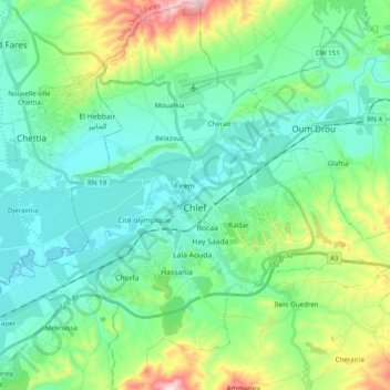
Nombre: Mapa topográfico Ash Shalif, altitud, relieve.
Lugar: Ash Shalif, Chlef District, Chlef, 02000, Algeria (36.09029 1.25950 36.24885 1.44872)
Altitud media: 179 m
Altitud mínima: 76 m
Altitud máxima: 522 m
Chlef lies in a valley at an elevation of 114 metres (374 ft) between two ranges of hills to the north and west. The city is surrounded by farmland; there are scattered trees both in the valley and on the hills.
Otros mapas topográficos
Haga clic en un mapa para ver su topografía, su altitud y su relieve.
Sendjas
Algeria > Chlef > Chlef District > Sendjas
Sendjas, Chlef District, Chlef, 02025, Algeria
Altitud media: 388 m