
Haz una donación
Mapa topográfico Sulur
Haga clic en el mapa para ver la altitud.
Haz una donación
Sulur
Sulur is located at 11°01′31″N 77°07′29″E / 11.0254°N 77.1246°E / 11.0254; 77.1246. It has an average elevation of 340 metres (1115 feet). Sulur is regarded as a pleasant town situated very close to the cities of Coimbatore "Manchester of South India" (19 km) and Tirupur (35 km). Thus it is a popular location for various textile mills and weaving slots. Near to Sulur there is a railway station and an Air Force base. The twin lakes to the north of the town, bounding the Coimbatore-Nagapattinam highway adds a scenic view to the town. The town is divided into two parts by the holy Noyyal River. Sulur is the East-end of the new Coimbatore district.
Haz una donación
Acerca de este mapa
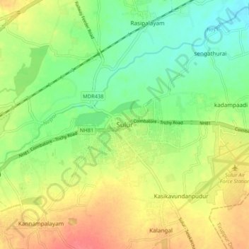
Nombre: Mapa topográfico Sulur, altitud, relieve.
Lugar: Sulur, Coimbatore, Tamil Nadu, 641402, India (10.98689 77.08586 11.06689 77.16586)
Altitud media: 371 m
Altitud mínima: 343 m
Altitud máxima: 405 m
Haz una donación
Otros mapas topográficos
Haga clic en un mapa para ver su topografía, su altitud y su relieve.