
Haz una donación
Mapa topográfico Mount Kinabalu
Haga clic en el mapa para ver la altitud.
Haz una donación
Mount Kinabalu
Mount Kinabalu (Malay: Gunung Kinabalu, Dusun: Gayo Ngaran or Nulu Nabalu) is the highest mountain in Borneo and Malaysia. With an elevation of 13,435 feet (4,095 m), it is third-highest peak of an island on Earth, and 20th most prominent mountain in the world by topographic prominence. The mountain is located in Ranau district, West Coast Division of Sabah, Malaysia. It is protected as Kinabalu Park, a World Heritage Site.
Haz una donación
Acerca de este mapa
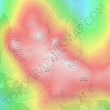
Nombre: Mapa topográfico Mount Kinabalu, altitud, relieve.
Lugar: Mount Kinabalu, Ranau, West Coast Division, Sabah, Malaysia (6.07502 116.55865 6.07512 116.55875)
Altitud media: 3,567 m
Altitud mínima: 2,661 m
Altitud máxima: 4,062 m
Haz una donación
Otros mapas topográficos
Haga clic en un mapa para ver su topografía, su altitud y su relieve.
Haz una donación
Kinabalu Park
Malaysia > Sabah > Ranau > Tinompok
The park headquarters is 88 kilometres away from the city of Kota Kinabalu. There are sealed roads leading towards the park headquarters from other parts of Sabah. It is situated on the southern boundary of Kinabalu Park, at an elevation of 1,563 m (5,128 ft).
Altitud media: 2,063 m