
Mapa topográfico Rye Harbour
Mapa interactivo
Haga clic en el mapa para ver la altitud.
Acerca de este mapa
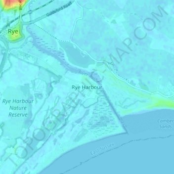
Nombre: Mapa topográfico Rye Harbour, altitud, relieve.
Altitud media: 2 m
Altitud mínima: -3 m
Altitud máxima: 43 m
Otros mapas topográficos
Haga clic en un mapa para ver su topografía, su altitud y su relieve.
Highwoods SSSI
United Kingdom > England > East Sussex > Rother > Bexhill-on-Sea
Highwoods SSSI, Bexhill-on-Sea, Rother, East Sussex, England, United Kingdom
Altitud media: 28 m
Bexhill-on-Sea
United Kingdom > England > East Sussex > Rother
Bexhill-on-Sea, Rother, East Sussex, England, TN39 3PE, United Kingdom
Altitud media: 13 m
Rye
United Kingdom > England > East Sussex > Rother > Rye
Rye, Rother, East Sussex, South East England, England, United Kingdom
Altitud media: 7 m
Battle
United Kingdom > England > East Sussex > Rother > Battle
Battle, Rother, East Sussex, England, United Kingdom
Altitud media: 66 m