
Mapa topográfico West Side
Mapa interactivo
Haga clic en el mapa para ver la altitud.
Acerca de este mapa
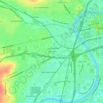
Nombre: Mapa topográfico West Side, altitud, relieve.
Altitud media: 232 m
Altitud mínima: 213 m
Altitud máxima: 269 m
Otros mapas topográficos
Haga clic en un mapa para ver su topografía, su altitud y su relieve.
Dayton
United States > Ohio > Montgomery County > Dayton
Dayton, Montgomery County, Ohio, 45423, United States
Altitud media: 270 m
Patterson
United States > Ohio > Montgomery County > Dayton
Patterson, Dayton, Montgomery County, Ohio, 45408, United States
Altitud media: 233 m
Residence Park
United States > Ohio > Montgomery County > Dayton
Residence Park, Dayton, Montgomery County, Ohio, 45428, United States
Altitud media: 266 m
Crown Point
United States > Ohio > Montgomery County > Dayton > Crown Point
Crown Point, Dayton, Montgomery County, Ohio, 45428, United States
Altitud media: 273 m