
Haz una donación
Mapa topográfico Khammam
Haga clic en el mapa para ver la altitud.
Haz una donación
Khammam
Khammam is located at 17°15′N 80°09′E / 17.25°N 80.15°E / 17.25; 80.15. It has an average elevation of 108 metres (390 feet).
Haz una donación
Acerca de este mapa
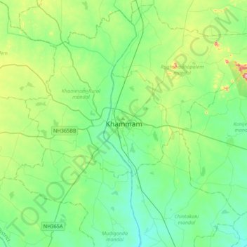
Nombre: Mapa topográfico Khammam, altitud, relieve.
Altitud media: 130 m
Altitud mínima: 73 m
Altitud máxima: 316 m
Haz una donación
Otros mapas topográficos
Haga clic en un mapa para ver su topografía, su altitud y su relieve.
Hyderabad
India > Telangana > Bahadurpura mandal
Hyderabad (/ˈhaɪdərəbæd/ HY-dər-ə-bad; ISO: Haidarābād, Telugu: [ˈɦaɪ̯daɾaːbaːd] , Urdu: [ˈɦɛːdəɾaːbaːd]) is the capital and largest city of the Indian state of Telangana. It occupies 650 km2 (250 sq mi) on the Deccan Plateau along the banks of the Musi River, in the northern part of…
Altitud media: 549 m
Greater Hyderabad Municipal Corporation East Zone
India > Telangana > Uppal mandal > Hyderabad
Altitud media: 515 m