
Haz una donación
Mapa topográfico Sankoo tehsil
Haga clic en el mapa para ver la altitud.
Haz una donación
Acerca de este mapa
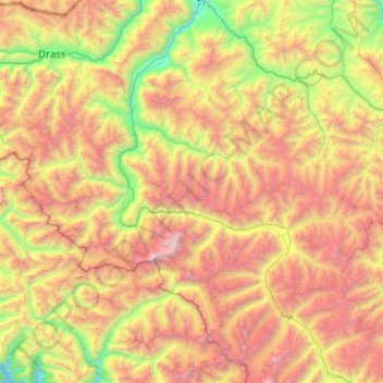
Nombre: Mapa topográfico Sankoo tehsil, altitud, relieve.
Lugar: Sankoo tehsil, Kargil district, Ladakh, India (33.75735 75.67287 34.49644 76.68629)
Altitud media: 4,410 m
Altitud mínima: 2,694 m
Altitud máxima: 7,057 m
Haz una donación
Otros mapas topográficos
Haga clic en un mapa para ver su topografía, su altitud y su relieve.
Karakoram Pass
Historically, the high altitude of the pass and the lack of fodder were responsible for the deaths of countless pack animals while the route was notorious for the trail of bones strewn along the way. There is an almost total absence of vegetation on the approaches to the pass.
Altitud media: 5,521 m
Haz una donación
Khardung La
The elevation of Khardung La is 5,359 m (17,582 ft). Local summit signs and dozens of stores selling shirts in Leh incorrectly claim its elevation to be in the vicinity of 5,602 m (18,379 ft) and that it is the world's second highest motorable pass.
Altitud media: 5,235 m
Haz una donación
Chang La
Chang La is a high mountain pass in Ladakh at an elevation of 5,391.3024 m (17,688.000 ft) in the Ladakh Range between Leh and the Shyok River valley. The Chang La, on Leh to Pangong Lake road, lies on the Leh-Karu-Sakti-Zingral-Chang La-Durbuk-Tangtse-Pangong Lake motorable road. Karu, which lies on…
Altitud media: 5,464 m
Haz una donación
Haz una donación
Haz una donación
Haz una donación
Haz una donación
Haz una donación
Kangju Kangri
India > Ladakh > Leh Tehsil
Kangju Kangri is a mountain in the Karakoram Range of Asia located in the union territory of Ladakh, India. With a summit elevation of 6,725 meters above sea level, it is the highest peak of the Pangong range, a subrange of the Karakoram. Kangju Kangri rises over the winding, tri-headed Kangju glacier and…
Altitud media: 6,190 m
Haz una donación
Haz una donación
Haz una donación
Haz una donación
Haz una donación