
Haz una donación
Mapa topográfico Union Canal
Haga clic en el mapa para ver la altitud.
Haz una donación
Union Canal
Canal commences from the sixteenth lock of the Forth and Clyde Navigation, about two miles west of Falkirk, in the county of Sterling , whence it takes an eastwardly course on the south side of the above-mentioned town, by some collieries; thence, through Black Hill Tunnel, and across the Glen Water, on which stream, at a short distance to the southward, is constructed a considerable reservoir. Its line hence is by Brighton Freestone Quarries, and about a mile north from Park Hill Colliery, to the Avon River, over which there is an aqueduct conveying the canal at an elevation of 80 feet above the surface of the river. The canal here enters the county of Linlithgow, and passes within a mile and a half on the south side of its capital, to Craighton House, where its course is more southerly and circuitous, to the River Almond, near Clifton House, where it crosses into Edinburghshire, by means of an aqueduct. Its course hence is by Ratho House, and across Leith River, to the city of Edinburgh, where it terminates by a basin at the Lothian Road, about half a mile south-west of the castle. The length of the canal is thirty miles , the depth of water 5 feet , and is on one level from Edinburgh to its western extremity, where it falls 110 feet , in one series of locks, into the Forth and Clyde Canal.
Haz una donación
Acerca de este mapa
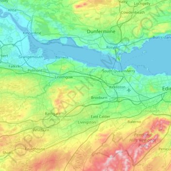
Nombre: Mapa topográfico Union Canal, altitud, relieve.
Lugar: Union Canal, Falkirk, Scotland, EH11 1HL, United Kingdom (55.91628 -3.84183 56.00172 -3.20805)
Altitud media: 136 m
Altitud mínima: -3 m
Altitud máxima: 564 m
Haz una donación
Otros mapas topográficos
Haga clic en un mapa para ver su topografía, su altitud y su relieve.
Falkirk
United Kingdom > Scotland > Falkirk
Falkirk is located in an area of undulating topography between the Slamannan Plateau and the upper reaches of the Firth of Forth. The area to the north of Falkirk is part of the floodplain of the River Carron. Two tributaries of the River Carron - the East Burn and the West Burn flow through the town and form…
Altitud media: 69 m
Haz una donación
Haz una donación
Haz una donación
Haz una donación
Haz una donación
Haz una donación
Haz una donación