
Mapa topográfico Safford
Mapa interactivo
Haga clic en el mapa para ver la altitud.
Acerca de este mapa
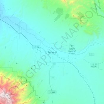
Nombre: Mapa topográfico Safford, altitud, relieve.
Lugar: Safford, Graham County, Arizona, 85548, United States (32.67395 -109.86758 32.99395 -109.54758)
Altitud media: 1,113 m
Altitud mínima: 839 m
Altitud máxima: 3,257 m
The climate is cold semi-arid (Köppen: BSk) softened by the plateau rise (it receives enough rainfall not to fall into a cold desert, BWk). It is much hotter than most places in eastern Arizona due to its relatively low elevation of 2,953 feet (900 m) at the Agricultural Center where records are kept, and often reaches temperatures almost as hot as found in Phoenix. In January, the average high temperature is 60 °F or 15.6 °C with a low of 29 °F or −1.7 °C. In July, the average high temperature is 98 °F or 36.7 °C with a low of 68 °F or 20 °C. Annual precipitation averages around 9.8 inches (248.9 mm), and snowfall is exceptionally rare: the mean is around 0.8 inches (0.020 m) but the median is zero.