
Mapa topográfico Mont Gosford
Mapa interactivo
Haga clic en el mapa para ver la altitud.
Acerca de este mapa
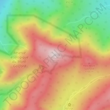
Nombre: Mapa topográfico Mont Gosford, altitud, relieve.
Altitud media: 933 m
Altitud mínima: 641 m
Altitud máxima: 1,178 m
Since 1978, Mount Gosford is included in "ZEC Louise-Gosford", a controlled harvesting zone open to the public. Recently, the areas at more than 700 metres of altitude were designated Important Bird Areas due to the presence Bicknell's thrushes, an endemic species living in mountain peaks of northeast North America.