
Mapa topográfico Sabden
Haga clic en el mapa para ver la altitud.
Acerca de este mapa
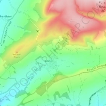
Nombre: Mapa topográfico Sabden, altitud, relieve.
Lugar: Sabden, Ribble Valley, Lancashire, England, United Kingdom (53.81592 -2.38007 53.85828 -2.30191)
Altitud media: 236 m
Altitud mínima: 91 m
Altitud máxima: 482 m
Otros mapas topográficos
Haga clic en un mapa para ver su topografía, su altitud y su relieve.
Billington and Langho
United Kingdom > England > Lancashire > Ribble Valley > Brockhall Village
Altitud media: 58 m
Old Langho
United Kingdom > England > Lancashire > Ribble Valley > Brockhall Village
Altitud media: 74 m
Brungerley Park
United Kingdom > England > Lancashire > Ribble Valley > Clitheroe > Waddington
Altitud media: 77 m
Mellor Brook
United Kingdom > England > Lancashire > Ribble Valley > Mellor Brook
Altitud media: 106 m