
Mapa topográfico Aberdeen
Haga clic en el mapa para ver la altitud.
Aberdeen
Two weather stations collect climate data for the area, Aberdeen/Dyce Airport, and Craibstone. Both are about 4 1⁄2 miles (7 km) to the north west of the city centre, and given that they are in close proximity to each other, exhibit very similar climatic regimes. Dyce tends to have marginally warmer daytime temperatures year round owing to its slightly lower elevation, though it is more susceptible to harsh frosts. The coldest temperature to occur in recent years was −16.8 °C (1.8 °F) during December 2010, while the following winter, Dyce set a new February high temperature station record on 28 February 2012 of 17.2 °C (63.0 °F)., and a new March high temperature record of 21.6 °C (70.9 °F) on 25 March 2012.
Acerca de este mapa
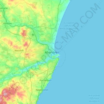
Nombre: Mapa topográfico Aberdeen, altitud, relieve.
Lugar: Aberdeen, Aberdeen City, Scotland, AB11 5EQ, United Kingdom (56.98824 -2.25281 57.30824 -1.93281)
Altitud media: 52 m
Altitud mínima: 0 m
Altitud máxima: 368 m
Otros mapas topográficos
Haga clic en un mapa para ver su topografía, su altitud y su relieve.